Powered By Blogger

Tuesday, 30 August 2011

Bunbury and Busselton Area

Safety Bay (South of Fremantle)
We were looking forward to the south west of the state as the travel distances between towns and places of interest being much shorter than the north. Also, the scenery down here is much different to the north and west, a bit like that in parts of NSW and Victoria.

Safety Bay and Carpark
There were several nice spots on the coast on the way down from Perth. We were able to call into many of these to see the fantastic views and scenery. We stopped 2 nights in Bunbury on Koombana Bay. Bunbury is a large city of about 51,00 people in the area. I think it's the 2nd largest outside Perth. They cater pretty well for tourists in all these towns and there are many walks including one along the waterfront near our park.
Koombana Bay Bunbury from Marlston Lookout

Unfortunately the weather wasn't the best when we were in Bunbury so we couldn't appreciate the place at its best. You can get a good view of the city and coastline from Marlston Hill lookout in the middle of the city. As in most places on WA's coast, there are lots of boats in their harbours. The Western Australians must be a rich lot!

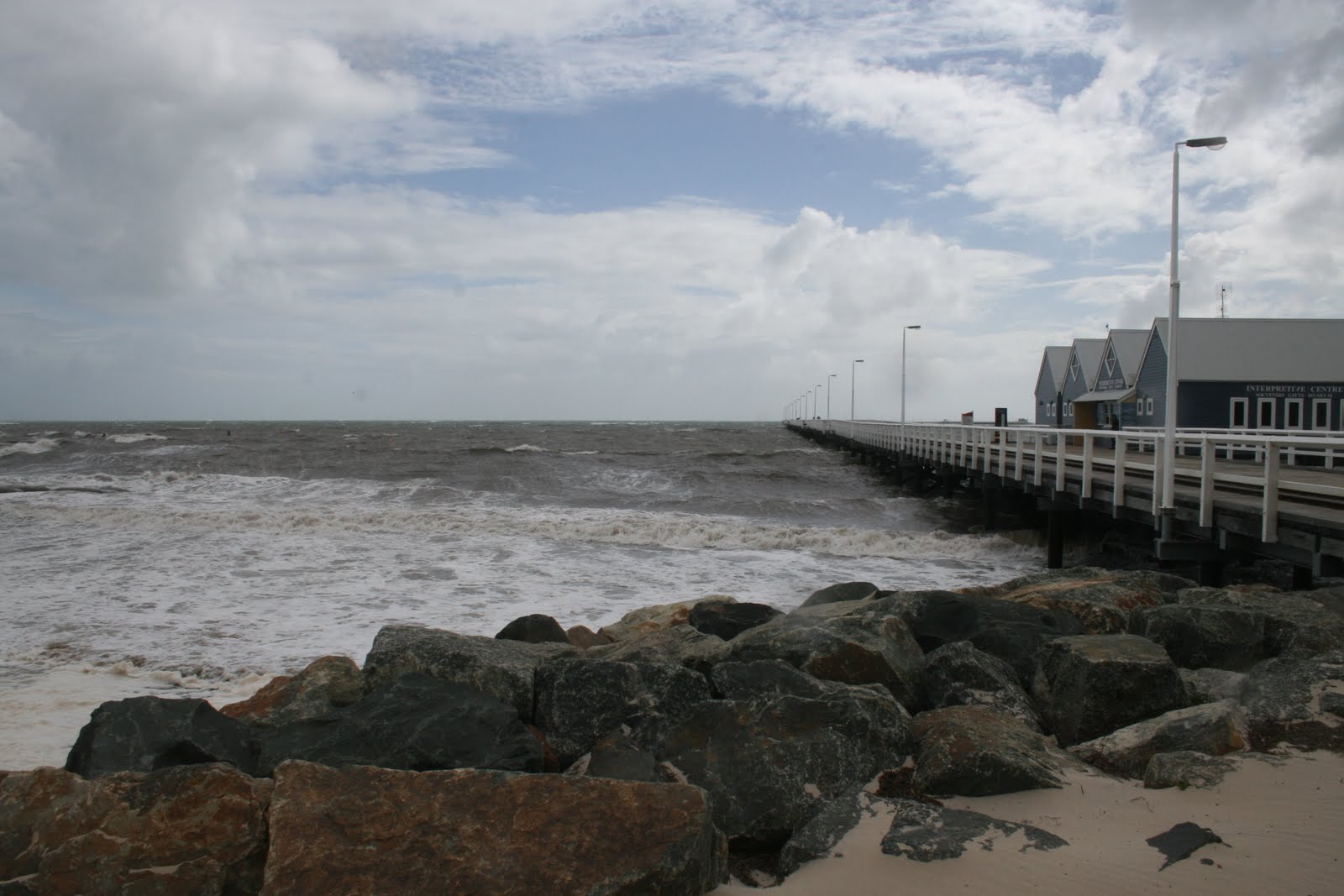
Diane and Peter on Windy Busselton Jetty

From Bunbury we drove down to Busselton, which is only 60Km away. We didn't stay long in Busselton as the weather still wasn't the best. We did, however, go out on the famous Busselton Jetty which is probably the most well known attraction here. At 1.8Km long, the jetty is the longest timber jetty in the southern hemisphere. It was built 145 years ago to enable goods to be shipped into and out of this region. They have an underwater observatory at the end of the pier and a small train ride out to the end. Due to the poor weather both of these were closed.
Busselton Jetty and Heritage Buildings

A lot of the town's activities are on and around the waterfront which would be a great place to be in good weather. There are also many good restaurants here and are visited by local, tourists and many people from Perth due to its location.

1.8 Km Long Busselton Jetty
We were told that there are 30Km of white beaches with crystal clear water around Busselton but it wasn't like that for us. We had to take their word for it as the water was pretty rough when  were there.


Busselton Jetty Shorebreak
Busselton is a resort town and also the gateway to the Geographe Bay area, Cape Naturaliste and the Margaret River region. There's enough here to spend several weeks visiting but we only had a couple of weeks. Busselton also has possibly the best caravan park in Australia. We didn't stay there but the people we spoke to who did raved about it. It's called the Mandalay Tourist Resort.


Surfing at Yallingup (near Dunsborough)
From Busselton we drove another 30 Km to Dunsborough, and stayed another 2 days there. The wet weather was still with us but still managed to get a few glimpses of sun and made the most of them. Although the weather didn't stop the surfers, we didn't venture into the water. I think we'll have to wait till summer now.

Sunday, 28 August 2011

Rottnest Island

Rottnest Coastline at Thomson Bay
We decided to take our bikes over to Rottnest and ride around the island. As our caravan park was relatively close to the ferry terminal, we rode the 4 Km from the park along the waterfront. This was an experience to see the old heritage buildings alongside the modern and all the boating facilities.
Cycling Around Rottnest

The Rottnest Express ferry trip takes about 25 minutes to travel the 19Km from Fremantle and costs $65.00 return for seniors. This also includes the "landing fee". Seemed a bit expensive to me but there's no other way of getting there. The ferries are very modern with TVs, food outlet, and comfortable seating. They run a few times in the morning and a few return trips later in the afternoon. No cars are allowed on the island so the only ways to get around are walk, cycle or bus. The normal thing is to hire bikes (they literally have hunderds for hire) or catch the hop on hop off bus. We were definitley in the minority with our own bikes.


Peter & Diane at Salmon Bay - Rottnest
The distance around the island's circuit road is about 24Km. Around the island there are 63 beaches and 20 bays, all with pristine waters and great scenery. We set off from the main area at Thomson Bay and intending to take about 4 hours to do the lap.


Porpoise Bay at Rottnest

Even though it was a coolish weekday, there were several other people doing the same as us. Cycling around the island is definitely the best way to go as you can make your own pace. The bus operates on a good schedule and you can get off at various locations, see the area, and get on the next one. There are several walking tracks off the main road enabling you to easily get to the beaches.
The Beautiful Waters of Porpoise Bay


View from Wadjemup Lighthouse
The water supply on the island is a combination of harvested rainwater, underground supplies and a desalinated groundwater system using the reverse osmosis process. Their electricity comes from wind turbines and a diesel generator system.The wind turbines deliver 37% of the island's requirements.
In 1996 Rottnest introduced the first public place recycling program in Western Australia. In 2000 the island won the 3R awards (reduce, reuse and recycle). A daily supply barge - Spinifex - makes a return trip from Fremantle, delivering supplies and removing rubbish.

Rottnest's Beautiful Geordie Bay

Rottnest Island was inhabited by Aboriginal people from about 30,000 years ago, until rising sea levels separated the island from the mainland of Western Australia approximately 7,000 years ago. The island was observed by the Dutch from 1610 with the first landing in 1658 The island was given the name "Rattenest" (meaning "rat's nest" in  Dutch) by the Dutch fleet captain Willem de Vlamingh on 29 December 1696. De Vlamingh described the indigenous marsupial, called a quokka, as a large rat.
Government House Lake on Rotnest

The eastern end of the island near the lighthouse, has some freshwater lakes. The colours are fascinating. One of them is a pink lake, the one next to it is bright blue. For whatever reason only one of the lakes contains  bacteria that create the pink colour.The lakes are populated by many different species of water birds and plants.

Lighthouse Keepers House from Bathurst Lighthouse

Rottnest was the site of an internment camp in both World War I and II. In WWI it was mostly used for German and Austrian suspected enemy aliens, before being closed towards the end of the war due to poor conditions. Also during World War II, two 9.2-inch guns were installed near the middle of the island at Oliver Hill, for defence of the Fremantle port. Two 6-inch guns were also installed at Bickley Point. The location of the island was seen as being crucial to the defence of the important port of Fremantle, the major base for the Allies in the Indian Ocean, as bombardment of any attacking ships could be made from the island before the ships would come into range of the port.

One of Rottnest's Delightful Quokkas

The quokkas are unique to Rottnest and not found on the mainland or anywhere else in the world.
We saw this quokka in the main tourist area of the island, apparently quite tame as it easily took food from us by hand. The quokkas are quite animals and have survived due to the absence of feral cats and foxes which would soon wipe them out.

Geordie Bay Looking East

The island became largely devoted to recreational use from the 1900s, aside from a brief period of exclusive military use during World War II. It is now visited by nearly 500,000 a visitors a year, an average of 330,000 of those arriving by ferry or air taxi per. 70% of all visitors come for the day only. The majority of visitors come in summer, with nearly 20% of all visitors coming in January. The island has accommodation for up to 2,850 visitors, while day-only visitors can number up to 5,000 at any one time. There are no private ownership on the island with the Rottnest Island Authority administering everything. Demand for accommodation is very high during the summer months, with ballots held annually for accommodation during the January and Easter school holiday periods.

Geordie Bay Looking West
The coastline of Rottnest is a remote and wonderful place which can best be enjoyed by getting around the island at your own pace. The roads are  mostly flat but a few hills sorted Diane out, especially at the end when she was just about worn out. We can certainly recommend a trip out to Rottnest for visitors to Perth and do it on a bicycle.
The next day we took off along the Perth to Bunbury Highway for a few weeks in the South - West of the state.

Friday, 26 August 2011

Perth and Fremantle

After a full day looking at the wildflowers, we got a bit short on time and started to run low on fuel and also somewhere to stay for the night. We ended up in Lancelin, on the coast about 100Km north of Perth. Too late for service stations and couldn't find a caravan park so we ended up staying in the Lancelin Hotel car park with another van. No problems as the place was pretty quiet. The next morning we drove to the beach for breakfast and had the view below from our door - nice eh? Lancelin is a small fishing town with an increasing appeal to tourists for all water activities, but we only stayed one night then drove down to Perth.

Lancelin Bay Area


Australian Ringneck Parrot in our Van Park in East Perth
On arrival in Perth we found the caravan parks to be very busy and had to check into a park in Hazelmere, East Perth, about 18 Km from the CBD. It was a quite park and OK for our needs. Completed our census form here. Had visits in the park from several Australian Ringneck parrots - very tame and took food from the hand. These birds are also called No. 28 parrots.
Perth's CBD from Kings Park

Along with the Swan River,Kings Park is one of the best attractions in Perth. It is a great place for families to gather and for tourists to see the Perth landscape. Even though it was late in the day when we were there, a number of people were gathering to relax on the lawn and take in the ambience. The views of the city and Swan River are spectacular.

Evening View of Swan River from Kings Park
Like the harbour is to Sydney and the Yarra is to Melbourne, the Swan River is the focal point for Perth. Boating and water sports are abundant and many entertainment spots and restaurants adorn the shoreline. We were fortunate to attend a Hatch (my former employer) dinner in the old Swan Brewery, on the banks of the Swan. A delightful evening and great to catch up with some old work colleagues. 

Peter, Allison and Family at Fremantle Harbour

Stayed a couple of days with Diane's cousin, Peter Evans and his wife Alison. On Sunday, they took us to a great fish and chips place, Kailis', on Fremantle waterfront - beautiful! Had a great lunch with Peter, Alison and some of their family.

Fishing Boats at Fremantle
As well as the many pleasure craft at fremantle, there are many fishing boats based here. They make a great sight sitting in the calm water. The water front area is very popular with the public, especially on weekends, when the atmosphere is buzzing.
Beautiful Heritage Building in Fremantle

Fremantle is a vibrant port city, about 20 minutes from Perth CBD at the mouth of the Swan River. Fremantle boasts the best preserved example of a 19th century port streetscape in the world with its world famous heritage buildings and a fascinating maritime and convict history. 

Swan River from Peter & Alison's Balcony
Peter and Alison have a great apartment on King's Park and overlooking the Swan. The views from their balcony are magnificent. The outlook is such that you could sit for hours just watching the river and the boats. It's especially peaceful at dawn and dusk when the air and water is still.


Perth CBD and Swan River from Burswood Entertainment Precinct

Another well know part of Perth is the Burswood Entertainment Complex. Situated across the Swan, this is an area comprising bars, restuarants, hotels ,shows and casino. Many of the overseas visitors to Perth either stay here or visit the area. The view across the river to the city is OK as well.


Black Swans on the Swan River
I don't know if we were lucky or if it is common, but while we were looking across the river a couple of black swans floated past. What a great sight, swans on the Swan River with the city in the background. I don't know for sure but I think the river is named after these particular birds.


Sandalford Winery in the Swan Valley


We took a tour to the Swan Valley, which was quite close to our Caravan Park in Hazelmere. From the visitors centre at Guildford, we drove around the Swan valley Food and Wine Trail. This is a 32 Km scenic loop taking in a number of wineries, breweries, restaurants, cafes, shops and roadside stalls. We stopped at a few places including a chocolate factory (to sample the free chocolate), a honey place where we bought some beautiful honey, a winery and a coffee place called Yahava where we sampled a number of different coffees. We were given a fascinating rundown of the coffee blending and grinding process and bought a couple of their varieties to use in our coffee machines at home and in the van. We can recommend a tour of the Swan Valley.

Boat Stacking at Fremantle Harbour
We left our park in Perth and drove the 30 minutes to Fremantle to prepare for our trip over to Rotnest the following day. On the way we noticed one of the boat storage facilities there. There are so many boats in Fremantle that they have to stack them for storage. They're not just dinghys either. Most of the boats are of the expensive variety. After driving around the exclusive Perth and Fremantle streets, we could see why this is a very affluent place. We saw several houses valued over 50 million dollars and one under construction which would end up being nearly 80 million. Amazing. Back to our caravan to prepare for the day trip over to Rotnest Island.

Sunday, 21 August 2011

The Everlastings Wildflower Trail

The countryside around Geraldton was as healthy as it could be. Plenty of crops in sparkling condition - we were blown away by the extent and colour of the wheat and canola crops - simply breathtaking. The country is certainly in great shape over here - the drought is long gone!

Canola Crops near Geraldton

Canola Crop


The following are photos of various wildflowers we saw on the Everlastings Trail. This is one of several wildflower trails in WA's south and runs from Mullewa south through towns such as Morawa, Perenjoi, Three Springs and Mingenew


Pink Everlastings
Scaivola Striata

Golden Everlastings


Blue Flowers

White Daiseys

Daiseys

Wildflowers and Farmland

Flowers grow right up to the Road

Fields of Wildflowers

Beautiful Canola Flower


This area comes alive in late winter and spring each year, when the displays of wildflowers appear  in bushland, fields and roadsides. The everlastings form vivid carpets across the plains, especially in pastoral areas. The star attraction is the wreath flower but unfortunately we were too early to see any of these. This area is particularly suited to wildflowers due to the combination of climate, farmland and bushland in close proximity and the geography of the land. You would need at least a week to see the area properly and the best time would be end August to October.
Left wildflower country and headed back to the coast.


Friday, 19 August 2011

Kalbarri and Geraldton

Rest Area at Galena Bridge on the Murchison River
From Shark Bay we travelled down the Brand highway towards Kalbarri. This was also a pleasant drive with the countryside looking in great condition. Stayed a night in another beautiful free camp area on the Murchison River. These are great spots and very popular with the grey nomads.
Galena Bridge Rest Area
Most of the rest areas are very well maintained with rubbish bins emptied regularly and toilets kept in good condition. Many of them are in ideal locations, on rivers or with good views and are always easily accessible. Also, the people who stop at these areas are usually very friendly and we exchange a lot of useful information with them.


Murchison River from Hawkes Head Lookout
Kalbarri National Park is a popular spot for WA people, probably due to its proximity to Perth and the southern WA towns. Kalbarri National Park is known for its spectacular scenery and red rock gorges that were cut from the landscape by the Murchison River. You can experience views of the gorges from one of the many lookouts including the famous Nature's Window where the vista is seen through a massive red rock frame. The Loop, Z Bend, Hawkes Head Lookout and Ross Graham Lookout are also popular for views over the sandstone cliffs. Unfortunately, we were there just after some heavy rains and only able to visit the Hawkes Head and Ross Graham lookouts.

Pristine Waters of the Murchison River
The heart of the national park is the Murchison River. This river is the second longest in WA and one of the best fishing spots. In the National Park, there are many spots open to the public in the form of picnic areas and swimming and fishing areas.


Sandstone Cliffs on the Murchison River
The Murchison is carved out of sandstone rock over millions of years creating the magnificent scenery. It was overcast the day we were there but still managed to get some good photos. The water is clear and good temp making it ideal for supporting abundant fish and bird life.


Gantheaume Bay at Kalbarri
Kalbarri is located on Gantheaume Bay on the Indian Ocean. The bay is popular among fishermen and leisure boats to access the ocean, but it's not an easy matter. There's a reef and rocky shelf that has to be negotiated and this can be hectic if there's a heavy surf running. You can just see the break in the background of the photo.

View South from Red Bluff
The coastline around Kalbarri is dominated by red rocks and cliffs. The red colour is from the high concentration of iron in the rock. Red Bluff has a great lookout due to it's height and location out into the bay.In the early days it was used as a landmark by mariners due to it's distinct shape and appearance.
View North from Red Bluff

Even though it was a rainy day, the water was still a beautiful aqua colour. This spot is great for whale watching but we were too late for the northern migration and too early for the southern migration.


Part of Kalbarri NP from Meanarra Hill Lookout
  Unfortunately the wet weather prevented us from going further into the park. We would like to have gone in to see the famous Nature's Window, The Loop and Z Bend, but the dirt roads had become too slippery and deemed too dangerous, even for 4WD vehicles. Will have to see these on the next trip! Nevertheless, what we did see was spectacular.

Geraldton Port from Sunset Beach

Headed down the coastal road to Geraldton which was only 160Km away. The road is very picturesque, following the coast most of the way. Geraldton is a growing city with about 37,000 people. It's a regional hub of the mid west with a pristine coastline and rolling hills to the east and framed by the Chapman and Greenough rivers. The region is an expanding destination for holiday makers from the south. The city has about the same climate as Balina in NSW so pretty good for winter breaks.

St Francis Xaviers Cathedral Geraldton
There are many old and historic buildings in Geraldton but we were particularly impressed with the St Francis Xaviers catherdal. A beautiful old building and school.
The city has all the facilities along with character pubs, modern shopping centres and quaint restaurants, particularly around the waterfront.

Sunset over Sunset Beach - Geraldton

Our caravan park was right on Sunset Beach which is a few Km north of the Geraldton CBD. This would normally be a beautiful beach but unfortunately the wind had blown a lot of seaweed in and partially covered the beach. The beaches here are OK for surfing and swimming but due to the prevailing winds, they are a mecca for windsurfers. Many of them have walkways and promenades and we were able to cycle along Sunset beach one afternoon. The above sunset photo was taken from our caravan park - pretty spectacular eh?
We knew about the WA wildflowers but thought it was too early for them. This was not true so after a few days in Geraldton, we decided to head inland towards Mullewa and seek out the Everlastings Wildflower Trail.