Powered By Blogger

Wednesday 14 September 2011

Esperance

The Esperance region of WA is one of Australia's fastest growing visitor destinations. It has a temperate climate all year round, very white sandy beaches and brilliant blue/aquamarine waters. Esperance was voted Australia's best town by the Australian Traveller Magazine in 2009 so you can see what the fuss is about. Many of the visitors claim it has the most beautiful coastline in Australia. We thought in went really close.

 View over West Beach Esperance
Bluehaven Beach Esperance

Twilight Beach Esperance

Twilight Beach
They have a walkway which runs along the waterfront from the town about for about 20Km west to the famous beaches. These beaches are all beautiful and it would be hard to pick the best one. The main beaches are West Beach, Bluehaven Beach, Salmon Beach, Ten Mile, Observatory Beach and Twilight Beach. The latter has been voted many times to be the best beach in WA.


Twilight Beach
Twilight Beach is a spectacular family beach with crystal clear water and snow white sands. The beach curves to the southwest and it becomes increasingly protected by its orientation and two large offshore rock outcrops. Although it was still cool when we were there, some people were swimming. The beach is patrolled during the summer months on weekends. Ten Mile Beach is the best swimming beach due to the rocky shore acting as a natural breakwater. Surfing is apparently good here. We were told that the local naturalist beach (otherwise known as nudist beach) was just west of here but we chose not to look.
Esperance Coastline

On the second day in Esperance I took the bike along the Great Ocean Cycle Way. There are certainly some of the best ocean views here you would see anywhere. There are a number of benches and information boards along the way to help with identifying the landmarks. The benches were handy as there were some pretty good hills on the way!

View East from Observatory Hill
There are so many places of interest in and around Esperance you would need a week or more to see them. Bays such as Wylie Bay, Hellfire Bay and Esperance Bay itself make up the coastline and a number of national parks with some of the largest remaining wilderness areas of WA are close by. The Cape Le Grand National Park is about 50Km east and is one of WA's best known and most spectacular. Unfortunately we didn't have time to visit this park but may get back in the future.

Sea Lion at Tanker Jetty Esperance
We took a walk out onto the Tanker Jetty which jutts out into Esperance Bay. This jetty was built as a deep water wharf in 1935 as an excellent facility to unload bulk fuel and load grain for export. It ceased this use in 1977 and is now a tourist attraction and used for fishing. We saw this large sea lion at the beach near the jetty and he created a lot of interest with his antics, especially when he beached himself and clapped to the crowd.

Esperance Viewed from the Tanker Jetty

Unfortunately the jetty is falling into disrepair with costs to restore the timber components becoming almost prohibitive. We heard the council engineer on the radio say the the timber jetty would eventually be closed any taken down and a new jetty, made from steel and concrete, built in its place.


Sammy the Seal - an Esperance Icon
A photographic icon in Esperance at the entrance to the Tanker Jetty is Sammy the Seal. It's supposed to be lucky if you rub his head.


Sealife Fountain on the Esperance Waterfront
This fountain has been built at the bottom of the main street in Esperance. Not sure what is is called but it impressed me with its design and focus on the local sea life. It looked like something you would find in Italy or Greece.


The Recherche Archipelago from Observatory Hill
Esperance is about 490 Km east of Albany on the Southern Ocean It has a population of around 11,00 people and is a flourishing tourist destination with a huge variety of accomodations. The first landing here was by two French frigates in 1792 who were on a mapping voyage of the Australian coast. They took shelter off Observatory Point. The ships were the L'Esperance (hence the towns name) and the L'Recherche. The L"Recherche Archipelago of 110 islands and 1500 islets in the area has been named after this second ship. The town attracted enormous attention in the 1950's when Amercian investors established large landholdings near Esperance. The success of their farming methods caused an influx of farmers from all parts of Australia which has helped to make Esperance the prosperous town it is today.
Would have liked much more time here but had to move on and up to Kalgoorlie, before coming back to cross the Nullarbor.

Stirling National Park - Wave Rock

Bluff Knoll Stirling National Park
The Stirling Ranges and National Park was another short drive north from Esperance. We stopped in a campground called Moingup Spring which is another park administered by the state's DEC. No power but at $10.00 per night with free gas BBQ, good amenities and nice peaceful environment - hard to beat that! The camp host was a very helpful older gentleman who insisted on taking me into the bush to see some wild orchids he had found. A picture of one of them is below. I think it's called a spider orchid.


Wild Orchid in Stirling Ranges


The rugged peaks of the Stirling Range rise from the lowlands much of which has been cleared for agriculture. The range stretches east to west for about 65 Km and is characterised by stark cliff faces, great views and coloured flowering plants. These plants are in bloom year round and we were fortunate to see and photograph some of them at Bluff Knoll lookout. The photo below was taken in poor light but the effect of the mountain silhouette against the colourful bushes in the foreground was spectacular


Stirling Ranges
Bluff Knoll is 1,099 metres above sea level and is one of only a few places to experience regular snowfalls in Western Australia, with some snow reported in most years. The last heavy snowfall was in  1992 when 20 cm of snow was recorded. The mountain is often shrouded in a mist which curls around the peaks and floats into the gullies. 

Bluff Knoll from Carpark
There is a track to climb the peak which is 3.7 Km each way from the carpark. It's a level 4 track and would take about 3 hours to climb and return. As we were running a bit short on time, I walked along the track for about 35 minutes to get and appreciation of the area. The photo above was taken from the track about 1 Km from the carpark.
Wildflowers at Bluff Knoll

The view from the summit encompasses the Stirling and Porongorup mountain ranges, as well as the coast near Albany. The WA tourist literature lists the walk to the summit among Australia's 25 best hikes and with views like this it's easy to see why. The authorities have regognised the popularity of this place and have constructed a great facility at the carpark comprising covered viewing platforms, amenities, walkways and information boards. They really do look after the tourists over here.


Pink Salt Lake near Lake Grace
From the national park we drove up to Lake Grace which is a small town of about 1400 people. not much here but  convenient place to stop before driving on to Hyden and Wave Rock. We `stayed in the local van park and were the only guests - that's how busy they were. One of the unique things about the Lake Grace area (called wave area) is that everyone waves to you. Not just passing motorists but people on the street, in their yards, everyone. They seemed to be a happy bunch.


Around this area there are a lot of salt water lakes. They are formed by salty water coming up out of the ground and settling in these lakes. Lake Grace is named after a large one of these lakes near the town. Some of the lakes have a distinctive pink colour caused (somehow) by the salty water or algae growing there. Its hard to see from the photo above but the appearance is a vivid pink.


Diane at Wave Rock near Hyden
On to the town of Hyden which is home to the famous Wave Rock. Hyden is a small town of about 250  people located 340Km east of Perth. Without doubt the town exists on the popularity of the Wave Rock and surrounding attractions. They get conservatively 140,000 visitors each year. It is the colour and shape of the rock and the colours of the wildflowers that attract the visitors. The rock and surrounding park and walking tracks are about 4 Km out of the town.

Wave Rock
The rock itself is a granite formation reaching 15m high and thought to be over 2,700 million years old. The wave rock is about 110m long on the northern side of a granite outcrop called Hyden Rock. It really does look like an enormous wave ready to break. It's colour of rusty red streaks and ochre and sandy grey make it truly spectacular. It also has a particular resonating effect where you can hear people talking from one end to the other, some 100 metres away.

Wave Rock Dam
The authorities have constructed a water catchment barrier along the top of the rock to catch rain water falling on to the main body of the rock area. This water is directed into a dam and is used as the main supply for the tourist park area and also for Hyden township. This is a great idea but it does take away from the appearance of the wave rock itself.


Wave Rock from Above
The wave rock formation has been caused by weathering and water erosion which has undercut the base and left a rounded overhang. Water from the local springs running down the rock during the wetter months deposits minerals onto the rocks surface adding to the unique colour pattern of the rock. In 1960, crystals from Hyden Rock were dated as being 2,700 million years old, amongst the oldest in Australia.


Peter at Hippo's Yawn
There are a couple of nice walks around the Wave Rock precinct, a short one of 3 Km out to Hippos Yawn and a longer one of about 7 Km. Both are flat and easy walking. Due to time constraints (we had to travel on to Ravensthorpe that afternoon) we decided to do the short walk. This walk took us along a pleasant path with the base of the rock formations on one side and native flora on the other. The walk ended at the place called Hippos Yawn and you can see why by the photo above. There are other unusual rock formations in the area such as the Humps, the Breakers, the Falls and the Mulka's Cave.
Also near Hyden is the State Barrier Fence. This was previously known as the Rabbit Proof  Fence and was constructed in 1907 in a bid to hold back the invading rabbits which were spreading across Australia from the east. It used 8,000 tonnes of materials but unfortunately it was a bit of a failure and didn't keep out all of those rascal  rabbits.
We thought the diversion up to Wave Rock was definitely worth it, although some of the local people thought otherwise. We headed back to the coast and towards Esperance where they say they have the best beaches in Australia. (Big Call!)

Monday 12 September 2011

Beautiful Albany

Albany's Little Beach
Albany is a city of about 30,000 people and is one of the oldest towns in WA. It was actually settled before Perth, in 1826, and is WA's first white settlement. We booked into one of the better van parks at Emu Point which is a recreational area on Middleton Bay at the entrance to Oyster Harbour.

One of their nicest beaches is Little Beach which is some 35Km to the east on Two Peoples Bay. The stairs from the car park lead directly on to the northern end of the beach.
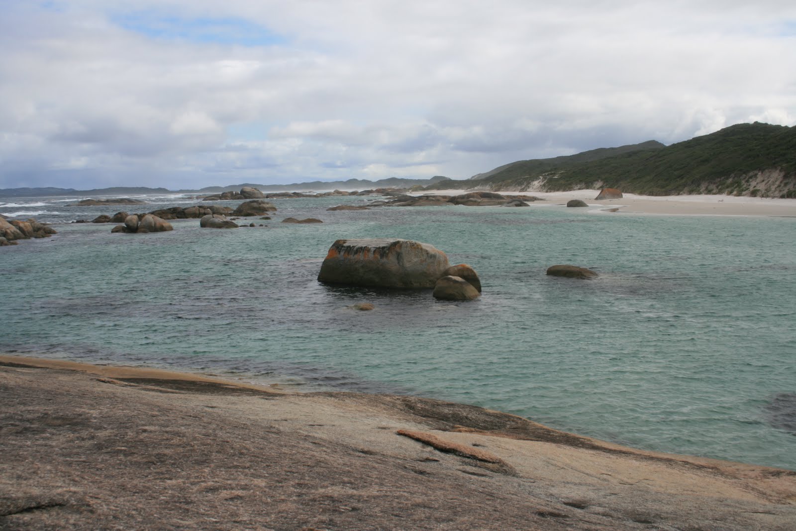

Little Beach
It is a beautiful walk along the beach to where a giant rock stands alone against the sea. Little Beach is somewhat sheltered by the headland and is blessed with bright turquoise waters and pure white sand. We could just imagine what it would be like in the summer when the water and air temperatures were warmer.It would be perfect for families or oldies to relax on the beach and a swim in the crystal clear water.

Little Beach - Two Peoples Bay
The rock formations make this beach different from any other - they are unique and make for beautiful pictures. The surf itself is ordinary as far as good waves are concerned but the scenery more than makes up for that. This is one of the must see places when visiting Albany.


Waterfall Beach
We stopped in to see another beach near Little Beach called Waterfall Beach.Waterfall Beach is a short walk over the headland from the south side of Little Beach in the Two Peoples Bay Nature Reserve.
A small waterfall winds its way to the ocean through a rock crevasse. This is a very small waterfall and in the drier weather you might even miss it. As you can see from the photo, the water is a beautiful turquoise, and the bay is sheltered from the sea.


Albany Coastline from Mt Clarence
Albany has many great walk/cycle ways and one of these went from Emu Point right along the waterfront and around Mt Clarence. We did a bike ride along here for about 10 Km and took in the magnificent views over King George Sound. Albany is located on one of the most beautiful natural harbours in the world. It would certainly rival Sydney harbour for beauty and its hard to understand why this place didn't become the capital of WA.


Albany Coastline at Entrance to Princess Royal Harbour
Albany has a medium sized port and the main use seemed to be grain. They have a large grain elevator complex which is used to ship out the products grown in the southern region of WA. This region is very fertile and has many prolific crops growing. The scenery is just fantastic and in stark contrast to the central and north of the state.
Albany was discovered by Captain Vancouver in 1791 and settled in 1826 - around 50 colonial buildings have survived and these now house museums, art and craft galleries and restaurants.


University Buildings at Albany
The photo shows one of the old buildings down near the waterfront which has been taken over by the University of WA. What a great building and location.


Replica of the Brig - Amity
One of Albany's attractions is the old brig, the Amity. This is a replica of the ship that brought Albany its first settler and convict cargo. The project to build a replica of the brig Amity commenced in 1972. When you see this full-size replica, its hard to imagine more than 50 men, together with stores, sheep and pigs, sharing this small vessel in a difficult journey that took more than six weeks.


Natural Bridge near Albany
To the south of the town and the Princes Royal harbour is a long peninsular, much of which is taken up by the world famous Torndirrup National Park. On one side of the peninsular is the local yacht club and various water sport facilities. On the southern side there are numerous natural attractions including the Gap, Natural Bridge, blowholes and a rugged coastline. The Natural Bridge is a large piece of granite rock which has been eroded over time by the huge seas of this area to form this arch.
.

Albany Coastline near the Gap
This coastline has some of the roughest seas in the country with the southerly winds whipping up waves from deep in the Southern Ocean which end up crashing into the shore here. At the time of our visit the water was relatively calm but evidence of  erosion of the rocks from large waves could be easily seen. We saw a few people fishing from the rocks here and they would have to have their wits about them as the sea can change very quickly. There were numerous signs warning about the dangers.


The Gap near Albany
Next to the natural bridge is the Gap. This is a sheer chasm which you can see from the safety of a steel caged viewing platform. The spray from the crashing sea 30m below sometimes reaches the platform. It's not quite the Gap in Sydney but spectacular nevertheless. I was able to get closer than the platform to get this photo.
Diane & Peter at the Gap - Albany
Whale Cooker for Extracting Oil
Probably the most popular tourist attraction in Albany is Whale World. Whale World is situated on the site of the old Cheynes Beach Whaling Station, located on the picturesque southern coast of King George Sound in Albany. The whaling station ceased whaling operations and was decommissioned in 1978.  Now an international tourist icon and educational attraction, it is also acknowledged as one of the State's most significant tourist attractions.


Skeleton of a Blue Whale
We joined a guided tour of the operations which took an hour and a half. This was most informative and we couldn't have got the information without doing the tour. We can recommend this tour. We saw how the whales were captured just of the coast of Albany, how they were dragged out of the water and onto the cutting platforms. It was a gruesome environment with blood and whale meat everywhere.

Wildflowers at Whale World


Whale Chaser Cheynes 1V
In its heyday, the whaling station had 4 whale chaser ships which spent about 8 months a year capturing whales. It must have been a hard life as the ships were very cramped and the crew worked long hours. They were well paid though but still most of them didn't last too long in the job. The ship above was used up until the station closed in 1978.


Whale Processing Area
The tour was very descriptive with visual and interpretive displays and sound recordings of what it was like to work here. One of the ladies on our tour had toured the operations here 40 years ago as a schoolgirl and she most remembered the smell. Apparently fresh whale meat and blood has a very distinctive and horrible smell. This didn't stop the workers who mostly wore shorts and singlet with little or no protective gear.
In addition to the tour there are 3D movies, a museum, photo gallery and a whale skeleton display. It is eye opening to see up close the size of the blue whale, the biggest species.

Cheynes Beach near the Whaling Station


The picture above is the beach next to the whaling station. When the station was operating there were sometimes dozens of whales floating in these waters waiting to be dragged ashore to be processed. Our guide told us he could remember the water here being red with blood and with a continual foul smell. Seeing the beach now, this was hard to imagine.
This was the last whaling station in Australia to cease operations so it was decided to make the place into what it is today to show the public how whaling was carried out. The whale meat was processed into oil to be used in a large number of products. This use has long since passed. Although sometimes eaten, whale meat was not sought after as it apparently is in Japan today.

We could have spent more time in Albany as there was lots more to see and do, but we had to move on and headed north again up to the Stirling National park and on to Wave Rock.


Sunday 11 September 2011

Denmark on WA's South Coast

View over Peaceful Bay Near Denmark
The trip down to Denmark and the South Coast from Pemberton was very scenic. We drove through some wildreness areas and stopped at the lookout in the William Bay National Park. Denmark is in the heart of the Great Southern and is listed in Lonely Planet's top 10 destinations in the world (so they say!). It is about 4 1/2 hours from Perth with a climate similar to Ulladulla so it would be great in the summer. The beaches and coastline are simply breathtaking.

Entry to Wilsons Inlet at Ocean Beach Point

Denmark is located on a large inlet called Wilsons Inlet. It's almost like a natural harbour but isn't deep enough for that. The scenery around the area is fantastic. It has about 100Kms of spectacular coastline and beaches. The Inlet itself is 20Kms long and is fed from the Denmark and Hay Rivers. Adjacent is the Nullaki Peninsula on the southern side. The whole area is very popular for boating, fishing and swimming.

Elaphant Rocks from the Lookout
We stayed in a park at Ocean Beach which is about 10K from the town right on the beach and entrance to the Inlet. We saw quite a few board riders out, some older guys as well. Its very popular for surfing, even though there wasn't much surf running at the time. The caravan park was one of the best we had stayed at. Must have been out of season though as there were only two other vans there (in a park that has 200 sites!)

Unique Elephant Rocks near Madfish Bay

Denmark is home to some of the region's most incredible wildflowers with whole areas in full colour. So we were told - unfortunately, we were again a few weeks too early for this. We have since met several people travelling over to WA, mainly to see the wildflowers in springtime. You could spend several weeks just travelling from region to region to see their flowers.
One of the most scenic areas in the district is the coastline of the William Bay National Park

Elephant Rocks
Greens Pool is rated one of WA's most idyllic beaches. It's located in a sheltered natural lagoon with glittering emerald water and pure white sand. The area is ideal for swimming, snorkeling and diving. The smooth, brown granite rocks seem unique to this region. The rocks at Elephant Rocks are aptly named - they are huge granite formations that resemble elephants as you can see from the photos. You can just make out Diane in this photo at the base of the big rock.

William Bay Coastline

Nearby to Denmark is the West Cape National Park which is home to the popular Shelley Beach.The road in is gravel but the scenery is worth the trip. Although we didn't take it, the trip to the top of Mt Lindesay is well worth it for the 360 deg view over the entire area including Wilson Inlet, Bennet Range and the Walpole Wilderness. There's only so much you can do on a trip like this.


Greens Pool
Denmark is surrounded by native woodland with a large variety of trees, including the eucalypts, marri, karri, jarrah and red tingle. A most distinctive local tree is the  red flowering gum


Looking East from Greens Pool

Denmark is a rural town with timber milling, orchards, beef cattle and dairy farming as its primary industries. Soil and climate attract wine growers, but tourism is the fastest growing business in Denmark. We could imagine what it would be like in the warmer months.

Western Australia's world-famous tingle trees are some of the most enormous trees in the world and can only be seen in WA's Southern Forests region.
They have a  Tree Top Walk here which soars 40 metres into the tingle canopy. It is similar to the Illawarra Fly near Robertson NSW.


Denmark Coastline

  We spent an enjoyable few days in Denmark and the nice van park and set off along the South Highway the distance of 51 Km to Albany, the largest town in the southern region